Showing posts with label Nature. Show all posts

Tuesday, December 31, 2013

උතුවන්කන්ද (සරදියෙල් ගල), Uthuwankanda (Saradiel Rock)

Scroll down to read in English.

කොළඹ සිට මහනුවර දක්වා නුවර පාරේ ගමන් ගන්නා ඔබට කෑගල්ල නගරයත් මාවනැල්ල නගරයත් අතරතුරදී ඔබේ වම්පසින් සුවිශේෂී හැඩයකින් යුතු ගිරිකුලක් නෙත ගැටී ඇති වාර ගණන අපමණය. එහෙත් ඉහත කී ගල "ලංකාවේ රොබින් හුඩ්" නමින් ප්‍රචලිත උතුවන්කන්දේ සූර සරදියෙල්ගේ තිප්පොල බව බොහෝ දෙනකු නොදන්නා කරුණකි.
සරදියෙල් ගලේ සමීප දසුනක් | A close-up of the Saradiel Rock
සූර සරදියෙල් යනු 19වන සියවස මැද භාගයේදී සුදු ආක්‍රමණිකයන්ට මහත් හිසරදයක් වූ මංකොල්ලකරුවෙකි. විශේෂයෙන්ම ඉංග්‍රීසි ප්‍රභූන්ගෙන් සහ තැපැල් කරත්තයෙන් සොරකම් කළ සරදියෙල් ඇතුළු ඔහුගේ කණ්ඩායම, ඔවුන් කොල්ලකෑ දෑ ගම්මුන් අතර බෙදා දුන්හ. මේ නිසාම සූර සරදියෙල් "ලංකාවේ රොබින් හුඩ්" නමින් විරුධාවලි ලැබීය.

කන්ද උඩරටට පිවිසෙන නිමේෂයෙහි පිහිටා ඇති මෙම මනරම් පර්වතය තරණය තරමක් වෙහෙසකරය. සරදියෙල් ගලේ මුල් භාගයේ රබර් වගා කර ඇතත් ඉහළට  ගමන් ගන්නා ඔබ පිවිසෙනුයේ කැලෑ ප්‍රදේශයකය. ගල මුදුනත එළිමහන් ගල් තලාවක් වන අතර එහි කොණෙක කොතක් වන් වූ උස් ශීර්ෂයකි. මෙම පර්වතය පුරා සරදියෙල් ඇතුළු සඟයින් සැඟව සිටි ගුහා පැතිර පවතින බව වාර්තා වේ.

පැයක පමණ කාලයක් තුල නැගිය හැකි සරදියෙල් ගලේ මුදුනේ සිට අවට සුන්දරත්වය මනාව රසවිඳිය හැකිය. මාවනැල්ල නගරයත් අවට ග්‍රාමීය පරිසරයත් ඔබේ දෙනයන පිනවන අතර අවටින් හමා එන සිහිල් සුළං දහර ඔබේ ගමන් විඩාව නිවනු නොඅනුමානය. සරදියෙල් ගලට යනෙන මගදී ඔබට කූඩැල්ලන්ගෙන් කරදර විඳීමට සිදුවනු ඇති බව සිත තබාගන්න.
ගලේ පාමුල සිට අවට අසිරිය | The surrounding panorama from the foot of the hill

පිවිසුම් මාර්ගය

A1 කොළඹ - මහනුවර ප්‍රධාන මාර්ගයට යාබදව පිහිටා ඇති උතුවන්කන්දට ලඟා වීම පහසුය. කොළඹ ප්‍රදේශයේ සිට මහනුවර දක්වා ගමන් කරන විටදී කෑගල්ල නගරයත් මොලගොඩ ප්‍රදේශයත් ඔබ පසු කර යා යුතුය. එසේ ගිය පසුව ඔබගේ වම් අතපසට 'උතුවන පාර' නමින් පාරක් හමුවන අතර එකී පටු මාර්ගය ඔස්සේ කි.මි.1ක් පමණ ගිය පසු හමුවන දෙමංසන්ධියෙන් වමට (කන්ද උඩට) තරමක් දුර ගිය පසු ඔබගේ රථය ගාල් කර පාගමිනින් කන්ද තරණය කළ යුතුය. මහනුවර දෙසින් ගමන් ගන්නේ නම් මාවනැල්ල නගරය පසු වී කි.මි.2ක් පමණ කොළඹ දෙසට ධාවනය කළැ යුතුය. මාවනැල්ල පසු කර එන ඔබට උතුවන පාර උතුවන්කන්ද මංසන්ධිය පසුකරනවාත් සමඟම සොයා ගත හැකිය ඇත.
Courtesy of Google Maps

අවට ආකර්ෂණයන්

උතුවන්කන්දේ සිට කොළඹ දෙසට වන්නට පිහිටි පින්නවල අලි අනාථාගාරය මෙන්ම මහනුවර අශ්‍රිතව පිහිටා ඇති ශ්‍රී දළදා මාළිගය, පේරාදෙණිය මල්වත්ත, උඩවත්ත කැලයද කාගේත් අවධානයට පාත්‍ර විය යුතුය. මීට අමතරව පිළිමතලාවේදී A1 මාර්ගයෙන් නික්ම ළඟා විය හැකි ලංකාතිලක සහ ගඩලාදෙණි විහාරත්, ඇම්බැක්ක දේවාලය සහ අම්බලමත් ගම්පොල සහ මහනුවර යුගයේ ප්‍රෞඩත්වය මැනැවින් විදහා පානු ලබයි.
කඳු මුදුනේ සිට පෙනෙන අවට සුන්දරත්වය | The panoramic view from the top of Saradiel Rock

පහසුකම්

සරදියෙල් ගල පාමුල "සරදියෙල් විලේජ්" නමින් නිවාඩු නිකේතනයක් පවත්වා ගෙන යනු ලබන අතර එය "සූර සරදියෙල්" තේමාව යටතේ ක්‍රියාත්මක වීම සුවිශේෂීත්වයකි. ග්‍රාමීය ආහාරපාන සපයන මෙම නිකේතනයේ නවාතැන් පහසුකම් මෙන්ම දෛනික සංචාර සඳහා පහසුකම්ද සපයනු ලැබේ.
මග දෙපස... | On the way...
On your journey from Colombo to Kandy along the A1 highway, a peculiar mountain can be seen towards your left hand side in between the townships of Kegalle and Mawanella. However, the fact that this is the hideout of Soora Saradiel, the man notoriously referred to as the "Robin Hood of Ceylon" is known to few.

Soora Saradiel was a famous highwayman who was a menace to the British colonials in mid 19th century. Saradiel earned a reputation of robbing from the British elites and their henchmen as well as robbing the postal carriages. Since he distributed the loot among the peasants of the region he came to be known as the "Robin Hood of Ceylon".

Perched at the threshold of Sri Lanka's hill country, ascending this mountain can be a tricky task. The foot of the mountain hosts a rubber plantation. However, as you move up the cliff, you'll gradually walk into a jungle. The peak of the mountain has an open area, towards a side of this open area lies a steep and towering apex. It's recorded that the caves which Saradiel and his clan of bandits used as hideouts are scattered across the mountain.
වෙල් යාය මැදින් පෙනෙන සරදියෙල් ගලේ චමත්කාරය | The majestic Saradiel Rock through the paddy fields
The Saradiel Rock can be ascended in about 1 hour. The peak of the rock offers an enchanting vantage point of the surrounding environs covering the Mawanella town and the villages surrounding it. The cold breeze at the top of the mountain is bound refresh you after the tiresome climb. However, do keep in mind that you might have to endure a few leech bites during your hike.

How to get there

Uthuwankanda is easily accessible due to its close proximity to the A1 highway connecting Colombo to Kandy. When travelling from Colombo, one must pass Kegalle and Molagoda before you find a narrow road towards your left named the "Uthuwana Road". Travel approximately 1km on that road until you reach a fork, where you should take the road to your left (up a hill). Here you'll have to park your vehicles and commence your hike on foot.  When travelling from Kandy, one must pass the Mawanella town and travel approximately 2km. Just after passing the Uthuwankanda junction, you may find the Uthuwana Road to your right.
කඳු මුදුනට... | To the peak...

Nearby attractions

A bit towards the Colombo side from Uthuwankanda is the Pinnawala Elephant Orphanage. The Temple of Tooth, Peradeniya Botanical Gardens and the Udawatthe jungle are worthy attractions in and around the city of Kandy. Additionally, the temples Lankathilaka, Gadaladeniya and the ruins at Embekka bear testament to the splendor of the Gampola and Mahanuwara eras. These three attractions can be accessed by turning out of the A1 at Pilimathalawa.
ගල මුදුනත | The top of the rock

 Facilities

A holiday resort named "Saradiel Village" is being run at the foot of Saradiel Rock. The resort runs under the theme of the renowned bandit "Soora Saradiel" and serves up rural dishes and provides day-outing facilities alongside accommodation.

Sunday, December 29, 2013

ඩෙල්ෆ්ට් දිවයින, Delft Island

Scroll down to read in English.

ශ්‍රී ලංකා සිතියම නිරීක්ෂණය කරන ඔබට යාපන අර්ධද්වීපය අවට දිවයින් සමූහයක් පිහිටා ඇති බව නෙත ගැටී ඇතුවාට සැක නැත. මෙකී දුපත් අතුරින් භූමි ප්‍රමාණයෙන් විශාලතම දූපත (වර්ග කි.මි.50ක් පමණ වූ) වන්නේ ඩෙල්ෆ්ට් (දෙමළ බසින් නෙඩුන්තීවු) දූපතයි. ඉන්දු-ලංකා දේශ සීමාවට කිලෝමීටර කිහිපයක් නුදුරින් පිහිටා ඇති මෙම දූපත අතීතයේ පටන්ම රාජ්‍යයේ ස්වෛරීත්වයට වැදගත්වූ සන්ධිස්ථානයක් වූ බවට ඉතිහාසය සාක්ෂි දරයි. ඩෙල්ෆ්ට් දූපතට එහි නම යොදා ඇත්තේ ලන්දේසීන් විසිනි. එම නාමය බොහෝ විට නෙදර්ලන්තයේ පිහිටා ඇති ඩෙල්ෆ්ට් නගරයෙන් උපුටාගන්නට ඇත.
ඉපැරණි බලකොටුව | The old fortress
ඩෙල්ෆ්ට් දූපතෙහි 5000කට අධික ජනතාවක් වාසය කරන අතර නාවුක හමුදාව විසින් ප්‍රදේශයේ ආරක්ෂාව තහවුරු කරයි. දූපතට වෙනමම ප්‍රාදේශීය සභාවක්, ප්‍රාදේශීය ලේකම් කොට්ඨාශයක්, මාර්ග පද්ධතියක් මෙන්ම දිසා රෝහල්, පොලිස්, බැංකු, තැපැල් හා පාසල් පහසුකම්ද මධ්‍යම රජය විසින් සපයා දී ඇත.

අතිරමණීය දූපතක් වූ ඩෙල්ෆ්ට් හී ඓතිහාසික නටඹුන් හා ස්මාරක රාශියකි. ඒවා බොහෝමයක් කොරල් පර සහ හුණුගල් භාවිතා කර ඉදි කර තිබීම විමතියට කරුණකි. ලංකාවේ වෙනත් ප්‍රදේශවලට වෙනස් වූ පරිසර පද්ධතියක් ඇති ඩෙල්ෆ්ට් දූපත ලංකාවේ වල් අශ්වයින් හමුවන එකම ස්ථානයයි. දිවයිනේ ප්‍රධාන ජීවිකාව ධීවර කර්මාන්තය වන අතර ඩෙල්ෆ්ට් වැසියන් දකුණු ඉන්දීය ට්‍රොලර් යාත්‍රා විසින් සිදුකරන මත්ස්‍ය මංකොල්ලයේ පීඩිතයන් බවට පත්ව තිබීම ඛෙදජනකය.

ඓතිහාසික පසුබිම

ඉන්දු-ලංකා දේශ සීමාවේ පිහිටා තිබෙන ඩෙල්ෆ්ට් දූපත ශතවර්ෂ ගණනාවක පටන් රාජ්‍යය පාලනයට උපක්‍රමික වැදගත්කමකින් යුතු ස්ථානයකි. දූපතෙහි උතුරු භාගයට වන්නට පෞරාණික විහාර පද්ධතියක නටඹුන් දැකිය හැකිය. ඒ අතුරින් දාගැබ් සමූහයක පාදම් විශේෂයෙන් කැපී පෙනෙයි.
බෞද්ධ නටඹුන් | Buddhist Ruins
තවත් ඉතාමත්ම වැදගත් ආකර්ෂණයක් වන්නේ ඩෙල්ෆ්ට් හී ඇති ඉපැරණි කොටුවයි. පළමුවෙන්ම යාපනය පාලනය කළ වන්නියාර් රජවරුන් විසින් ඉදිකරන්නට යෙදුනු මෙම බලකොටුව පසුකාලීනව යුරෝපීය ආක්‍රමණිකයන් විසින්ද සිය ආදිපත්‍යය පැතිරවීම සඳහා යොදා ගෙන ඇත. මෙම කොටුවෙහි ඇති වැදගත්කම නම් එය මුළුමනින්ම පාහේ කොරල් පර යොදාගෙන කර තිබීමයි. ඊට බදාමය ලෙස හුණු, බිත්තර සහ කෝමාරිකා යුෂ එකතු කොට සකසා ගත් සම්මිශ්‍රණයක් භාවිතා කෙරුණු බවට විශ්වාස කෙරේ. ලන්දේසි සහ බ්‍රිතාන්‍ය පාලනය යටතේ ශක්තිමත් කෙරුණු මෙම බලකොටුව 1960 දශකය දක්වා ඉතාමත්ම හොඳ තත්ත්වයක පැවැතුණු බවත්, එවක හැමූ සුළිසුළඟින් දැඩි අලාභහානියට පත්වූ බවත් දූපත්වාසීන් පවසති. ඩෙල්ෆ්ට් රෝහල හරහා ළඟා විය යුතු මෙම බලකොටුව නිසියාකාරයෙන් සංරක්ෂණය කිරීම බලධාරීන් සතු යුතුකමකි. 

බලකොටුවට අමතරව ඓතිහාසික ලන්දේසි රෝහලක් මෙන්ම බ්‍රිතාන්‍යයන් විසින් 1905දී කැරවූ උසාවියකද නටඹුන් ඩෙල්ෆ්ට් හී අදටත් ඉතිරිව පවතී. ඉපැරණි බ්‍රිතාන්‍ය උසාවිය අසල තවමත් නිකැලැල්ව ඉතිරිව පවතින්නේ පරෙවි කූඩු සහිත ස්ථම්භයකි. අතීතයේදී ඩෙල්ෆ්ට් දූපතේ සිට ගොඩබිමට පණිවිඩ යැවීමට යොදාගත් පරෙවියන්ගේ වාසස්ථානය වූයේ මේ ස්ථම්භයයි. අතීතයේදී ඩෙල්ෆ්ට් බලකොටුවත් උසාවි භූමියත් යා කෙරෙන උමගක් ප්‍රාදේශීය පාලකයන් විසින් කරවූ බවද කියැවේ.
ඩෙල්ෆ්ට් කොටුව | Delft Fort

පරිසර සුන්දරත්වය

ඩෙල්ෆ්ට් දූපතේ ඇත්තේ ශුෂ්ක පරිසර පද්ධතියකි. ගල් සහ වැලි සහිත පසකින් ආඪ්‍ය ඩෙල්ෆ්ට් දූපත පුරා තල් ගස් පැතිර පවතී. දූපතේ වැටමායිම් සලකුණු කිරීමටද කොරල් පරවලින් කරවූ ප්‍රාකාර යොදා ගැනීම අතිශය විශ්මයජනකය.
ශුෂ්ක දේශගුණය | Arid weather
හින්දු විශ්වාසයට අනුව ඩෙල්ෆ්ට් දූපත නිර්මාණය වී ඇත්තේ හනුමන්තා හිමාලයෙන් රැගෙන ගිය ඖෂධ වනයෙන් කොටසක් මුහුදට වැටීමෙනි. ඩෙල්ෆ්ට් දූපතෙහි ඖෂධීය ශාක විශේෂ 62ක් පවතින බව කියැවේ. ඒ අතුරින් කෝමාරිකා, හීරැස්ස වැනි ශාක සුළභව දැකිය හැකිය.

දූපත මධ්‍යයෙහි සුවිශාල බඔබාබ් ගසක් දක්නට ලැබෙන අතර එහි කඳේ සුවිශාල බෙනයක් දක්නට ඇත. මෙවන්ම ගසක් මන්නාරමේද දැකිය හැකිය. අප්‍රිකාවේ බහුලව දක්නට ලැබෙන මෙම ශාකය බොහෝ විට පෘතුගීසීන් විසින් ඩෙල්ෆ්ට් දිවයිනට ගෙන එන්නට ඇත.


වල් අශ්වයින් නිසා ඩෙල්ෆ්ට් දූපත දේශීය සංචාරකයන් අතර ඉමහත් ප්‍රසිද්ධියක් අත් කරගෙන ඇත. පෘතුගීසීන් විසින් දූපතට හඳුන්වා දුන් අශ්වයින් පසුකාලීනව වල්වැදීම නිසා ලංකාවේ නිදැල්ලේ සැරිසරන අශ්වයින් ඇති එකම ස්ථානය ලෙස ඩෙල්ෆ්ට් දූපත නම් දරයි. පෘතුගීසී සමයේදී ඩෙල්ෆ්ට් දූපත අශ්ව අභිජනන සහ හුවමාරු මධ්‍යස්ථානයක් වන්නට ඇතැයි සැලකේ.කෙසේ වෙතත් දිවා කාලයේ දැඩි හිරු රෂ්මියත් සමඟ අශ්වයින් කැලෑ වදින අතර ඔවුන් රංචු වශයෙන් බහුලව දැකගත හැකිවන්නේ උදෑසන හෝ සවස් යාමයේ යැයි දූපත්වාසීන් පවසති. එනමුත් දිවා කාලයේද දිවයින පුරා යහමින් පැතිර පවතින එළිමහන් තෘණභූමිවල ගැවසෙන වල් අශ්වයින් ඔබට දැක ගත හැකිවනු ඇත. ඩෙල්ෆ්ට් දූපත පුරා වල් අශ්වයින් 450ක් පමණ වාසය කරතැයි ඇස්තමේන්තු කෙරේ. අවාසනාවකට මෙන් ආහාර හා ජල හිඟය නිසා වියළි කාලවලදී අශ්වයන් මියයන බව අපට අසන්නට ලැබිණි. නවික හමුදාව මෙම සත්ත්ව සම්පත ඩෙල්ෆ්ට් දිවයිනේ ආරක්ෂා කරගනුවස් මහත් පරිශ්‍රමයක් දරණ බවද මෙහිලා ලිවිය යුතුමය. ඉදිරියේදී මේ සඳහා අක්කර 100කින් සමන්විත වනජීවී උද්‍යානයක් නම් කිරීමට රජය කටයුතු යොදමින් සිටින බව අපට වාර්තා වේ. එමඟින් කුරුළු විශේෂ 101කට, සමනල විශේෂ 15කට, ක්ෂීරපායී විශේෂ 11කට, කුරුමිණි විශේෂ 10කට, උරඟ විශේෂ 8කට මෙන්ම එක් උභයජීවී විශේෂයකට රැකවරණය සැපයෙනු ඇත.
වල් අශ්වයෙක් | A wild horse
ඩෙල්ෆ්ට් දූපතෙහි ඉතා විශ්මයජනක ස්වභාවික ශෛලමය නිමැවුම් දෙකකි. ලියලන ගල නමින් ප්‍රසිද්ධ ගල දිනෙන් දින නාග පෙනයක හැඩයෙන් වර්ධනය වන බව දූපත්වාසීන් පවසන අතර, එය හින්දූන්ගේ පූජාවටද ලක්ව ඇත. මීට අමතරව අසිරිමත් සුවිසල් පාද ලාංඡනයක්ද දූපත් මධ්‍යයෙහි දක්නට ලැබේ. මෙය හනුමන්තාගේ පා සටහන බව ඇතැමුන්ගේ විශ්වාසයයි. මෙම පාද ලාංඡනයට නුදුරින් අතීතයේදී අශ්වයින් ගාල් කිරීමට යොදා ගැනුණු ඉස්තාලවල ශේෂයන්ද දැකිය හැකිය. 

මීට අමතරව ඩෙල්ෆ්ට් දූපතේ නැගෙනහිර ඉවුරේ දැකුම්කළු නොගැඹුරු වෙරළ තීරයක්ද දැකිය හැකිය.
හනුමන්තාගේ බවට කියැවෙන පාද ලාංඡනය | The footprint believed to be Hanuman's

පිවිසුම් මාර්ගය

දූපතක් වන ඩෙල්ෆ්ට් වෙත ඔබට ලඟා විය හැක්කේ සමුදුරු තරණයෙනි. නාගදීපයට යාත්‍රා කෙරෙන මගී නෞකා ගමන් ආරම්භ කෙරෙන කුරිකඩ්ඩුවාන් ජැටියෙන් දිනපතා උදෑසන 9ට ඩෙල්ෆ්ට් බලා මගී යාත්‍රාවක් ගමන් අරඹයි. මහාමාර්ග සංවර්ධන අධිකාරිය විසින් නොමිලේ ක්‍රියාත්මක කෙරෙන මෙම සේවාව ඩෙල්ෆ්ට් දිවයිනෙන් හවස 2.30ට යළිත් කුරිකඩ්ඩුවාන් බලා ගමන් අරඹයි. මෙම මුහුදු ගමනට පැයක කාලයක් වැය වේ. ඩෙල්ෆ්ට් දූපත දක්වා ක්‍රියාත්මක වන එකම පොදු ප්‍රවාහන සේවය මෙයයි, එබැවින් මෙම සේවාව මග නොහැරෙන ලෙස දිනය සැලසුම් කරගන්න. ඊට අමතරව කුලී පදනම මත රුපියල් 8000කට ආසන්න අගයකට (එක පැත්තකට) ඔබට බෝට්ටුවක් කුලියට ගැනීමේ හැකියාවද පවතී. 

යාපනය සිට සපත්තු පාලම් ඔස්සේ වේලනෙයි හරහා කුරිකඩ්ඩුවාන් ජැටියට කි.මි. 30ක් ගෙවා ළඟා විය හැකිය. එහිදී ඔබට ඔබගේ රථය ගාල් කිරීමට අවශ්‍ය පහසුකම් වේලනෙයි ප්‍රාදේශීය සභාව සහ ආරක්ෂක අංශ මැදිහත්ව සපයා දී තිබේ. 
ඩෙල්ෆ්ට් ජැටිය | Delft jetty
ඩෙල්ෆ්ට් දිවයිනේ ජැටියට නෞකාව ළඟා වූ පසු ජැටිය අසලින් ඩීමෝ බට්ටකු හෝ ත්‍රී රෝද රථ ඔබට කුලියට ගත හැකි අතර ඒවාහී රියැදුරන් ඔබව දූපත වටා පිහිටා ඇති වැදගත් සන්ධිස්ථාන කරා පැය දෙකක් ඇතුලත ගෙන යනු ඇත.

අපගේ ගමනේදී අප ඩෙල්ෆ්ට් දූපත වටා ගමන් ගත්තේ කමල් නම් රියැදුරකු සමඟ ත්‍රී රෝද රථයකය. දූපත පිළිබඳව තොරතුරු රැසක් හෙළි කළ කමල් සමස්ථ ගමනටම අය කළේ රුපියල් 1500ක් පමණි.  
(ඉහත කී වේලාවන් සහ මිල ගණන් 2013 දෙසැම්බරයේ තත්ත්වය බව කරුණාවෙන් සලකන්න)
ඩෙල්ෆ්ට් දිවයින කරා | Towards Delft

අවට ආකර්ෂණයන්

සොළොස්මස්ථානවලින් එකක් ලෙස බෞද්ධයින්ගේ සිත්ගත් නාගදීපයට කුරිකඩ්ඩුවාන් ජැටියේ සිටම ළඟා විය හැකිය. නාගදීප (නයිනතීවු) දුපතේම නාගපූෂණී අම්බාල් නමින් වැදගත් හින්දු කෝවිලක්ද පිහිටා ඇත. මීට අමතරව යාපනයේ සිට කුරිකඩ්ඩුවාන් කරා දිවෙන මාර්ගයට නුදුරින් පිහිටා ඇති චට්ටි වෙරළතීරයටත්, අරාලි තුඩුවේ පිහිටි ජනරාල් ඩෙන්සිල් කොබ්බෑකඩුව මැතිඳුන්ගේ ස්මාරකයටත් ළඟා විය හැකිය.


පහසුකම්

යාපන අර්ධද්වීපයේ සිට මුහුදුන් සැලකිය මනා දුරකින් ඩෙල්ෆ්ට් දූපත පිහිටා ඇති නිසා ඔබට අවශ්‍ය කරන දෑ නෞකාවට ගොඩ වීමට මත්තෙන් සූදානම් කරගන්නේ නම් මැනවි. ඩෙල්ෆ්ට්හී දැනට මූලික පහසුකම් යටතේ හෝටලයක් ක්‍රියාත්මක අතර තවත් හෝටල් කිහිපයක් ඉදිවෙමින් පවතී. දූපතේ ජංගම දුරකථන සහ අන්තර්ජාල පහසුකම්ද ඇත. 
බඔබාබ් ගස | The Baobab tree
If you keenly observe the Sri Lankan map, you would've definitely come across a cluster of small islands towards the west of the Jaffna peninsula. Delft (known in Tamil as Neduntivu) is the largest out of these islands with approximately 50 sq.km of land. Located a few kilometers away from the Indo-Lanka border, this island was a crucial outpost for territorial integrity from the ancient times. Delft has got its name from the Dutch settlers who probably named the island after the Dutch city of Delft. 

The population of Delft exceeds 5,000 and the security of the island is provided by the Sri Lanka Navy. The island has a separate Pradeshiya Sabha, Divisional Secretariat, a road system alongside facilities such as a district hospital, banks, police, postal services and schools provided by the government.

A island of tranquility, Delft has a number of ruins and monuments. The fact that most of these have been erected using corals and limestone is quite fascinating. Delft has a bio system that is different to that of the rest of Sri Lanka and remains the only place in Sri Lanka where wild horses roam free. Fisheries is the main source of income for the island dwellers, however, it's sad to see how they are been severely impacted by the illegal mass fishing operations carried out by south Indian trawlers.
බ්‍රිතාන්‍ය උසාවිය | The British court

Historic background

Due to its close proximity to the Indo-Lanka border, the Delft island has been a strategically important location for centuries. Towards the northern side of the island remnants of Buddhist temple complex is visible with several bases of stupas (dagobas) scattered across. 

Another key attraction in Delft is the Fort. First constructed by the Wanniar rulers of the Jaffna peninsula, the fort was extensively used by the colonial rulers to stamp their authority in the region. The fact that the fort seems to have been constructed solely using dead corals stands out. An adhesive made out of lime, aloe vera and eggs is said to have been used as mortar to bind the corals together.  The fort has been in immaculate condition till the 1960s thanks to the activities of the Dutch and the British. However, the gale winds of the 1960s has damaged the fort to a considerable extent. Accessible through the Delft district hospital, it's the duty of the authorities to restore and protect this wonderful fort for future generations.
ඉපැරණි ලන්දේසි රෝහල | The old Dutch Hospital
In addition to the fort, a ruined Dutch Hospital and a ruined British Court build in 1905 is also remnant in the island. A pillar with pigeon holes stands in tact alongside the court. The pillar had housed the messenger pigeons used in the colonial era to communicate with the mainland. The island dwellers believe that there was a tunnel connecting the court premises with the fort built by the regional rulers centuries back.
පරෙවි කූඩු | Pigeonholes

Eco system

Delft possesses an arid weather and is littered with rocky and sandy soil. Palmyrahs are a common site in the island and the fact that fences made out of corals are used to demarcate lands is fascinating. 

According to Hindu belief Delft had been created by a piece of the Himalaya mountains that the god Hanuman had been carrying. The island has 62 types of ayurvedic plants out of which types such as aloe vera and Heeressa are very commonly seen.
ඩෙල්ෆ්ට්හී වල් අශ්වයෙක් | Another wild horse from Delft
A massive Baobab tree which has a large hollow inside is seen on the island. A similar tree can be seen in Mannar as well. A tree commonly seen in Africa, it is probable that the tree was planted in Delft by the Portuguese.

Delft has earned quite a reputation among local tourists for its wild horse population which is around 450. The Portuguese are believed to have introduced horses to Delft and used the island as a breeding and trading hub. However, later on these horses have been neglected and found their way to roam free in the islands creating Sri Lanka's only wild horse population. Due to the heat the wild horses can only be seen scattered across large open grasslands here and there during the day time. They roam in herds during the evening and the morning. Unfortunately a number of horses perish during the dry season due to famine. The actions taken by the Sri Lanka Navy to ensure the survival of these horses is commendable. Presently steps are afoot to name a 100 acre Wildlife Park in the island which will provide sanctuary to 101 species of birds, 15 species of butterflies, 11 species of mammals, 10 species of dragonflies, 8 species of reptiles and one specie of amphibians.
ලියලන ගල | The sprouting rock
Delft also hosts two amazing rock based creations. One of them is a sprouting rock which grows in size and stature to resemble the hood of a cobra. This rock is considered sacred by the Hindus. In addition a large footprint is seen towards the center of the island. Some believe it to be the footprint of god Hanuman. Adjacent to the footprint lies the ruins of what used to be the stables used to herd the horses in the times past. 

Additionally, there's an attractive and shallow beach towards the east coast of the island. 
වෙරළ තීරය | The beach

How to get there

Delft Island is accessible to civilians only through a sea voyage. The Road Development Authority operates a passenger ferry service free of charge to Delft from Kurikadduwan jetty, which is the same jetty used to provide ferry services to Nagadeepa. The ferry departs Kurikadduwan at 9.00am daily and makes the return voyage from Delft at 2.30pm. The journey by sea takes exactly 1 hour under mild sea and weather conditions. This is the sole public ferry service operating to Delft, so be mindful not to miss it. The other option would be to hire a boat which would cost you around Rs. 8,000 (one way). 
කුරිකඩ්ඩුවාන් ජැටිය මුහුදේ සිට පෙනෙනයුරු | Kurikadduwan jetty from the sea
From Jaffna a road connects to Kurikadduwan via Velanai thanks to an intricate system of causeways. The distance between Jaffna and Kurikadduwan is 30km. Parking facilities for your vehicles are provided at Kurikadduwan by the Velanai Pradeshiya Sabha and the security forces.

Once you berth on Delft you will need to hire a Dimo Batta mini truck or a three wheeler to traverse through the vast island. The drivers will take you to places of interest within a couple of hours. 

On our voyage there, we met Kamal who took us around Delft on a trishaw. He provided a lot of information about the island and only charged Rs. 1,500.
(Please note that the times and prices cited above are as at December 2013.)
ඩෙල්ෆ්ට්හී මංමාවත් | Roads in Delft

Nearby attractions

Nagadeepa, which is considered to be one of the 16 noblest places of worship for Buddhists in Sri Lanka (Solosmasthana) can be accessed through ferry from the Kurikadduwan jetty. The Nagadeepa island (referred to as Nainativu by the Tamil people) hosts the Nagapooshani Ambal Kovil which is considered an important Hindu temple. Additionally, you can drop by to the Chatty beach and the General Denzil Kobbekaduwa Monument in Araly Point which are situated along the road connecting Jaffna to Kurikadduwan.
කොරල් ගල් කොටුව බැඳීමට යොදාගෙන ඇති අයුරු | Corals used to erect the fortress

Facilities

Since Delft is situated miles away from the mainland, it's advised for you to arrange everything you may require before boarding the ferry at Kurikadduwan. At present, there's a hotel operating in Delft under basic facilities whilst several hotels are under construction. The island has mobile and internet connectivity.

Saturday, November 16, 2013

බඹරකන්ද, Bambarakanda

Scroll down to read in English.

"ලංකාවේ උසම දියඇල්ල කුමක්ද?" කුඩා කළ පාසලේදී නිතර ඇසෙන සාමාන්‍ය දැනීම ප්‍රශ්නයකි. මෙයට පිළිතුර බඹරකන්ද දියඇල්ල බව කොයිකවුරුත් පාහේ දනී. බඹරකන්ද, එසේත් නොමැති නම් බමරකන්ද ලෙසින් ලෝ ප්‍රචලිත මෙම දියඇල්ල දුන්හිඳ, ඩෙවොන්, සෙන්ට් ක්ලෙයාර්, දියලුම ආදී දියඇලි තරම් ආකර්ෂණීය නොවෙතත් ඔබේ අවධානයට පාත්‍ර විය යුතු දැකුම්කළු දියඇල්ලකි. හොර්ටන් තැන්නෙන් පෝෂණය වී වලවේ ගඟ කරා පියමනින බඹරකන්ද දියඇල්ල උසින් මීටර 263කි. බඹරකන්ද ලෝකයේ උසම දියඇලි අතුරින් 344වන තැන ගනී. ජෛව විවිධත්වය අතින් අගතැන්පත් ප්‍රදේශයක පිහිටා ඇති බඹරකන්ද දියඇල්ල පෝෂණය වන්නේ තරමක කුඩා දිය දහරකිනි. දියඇල්ලෙන් ගලා වැටෙන ජලදහර පතිත වන්නේ දියඇල්ල පාමුල පිහිටි නොගැඹුරු ස්වාභාවික තටාකයටය. තරමක විශාලත්වයකින් යුක්ත වූ මෙම තටාකයද අතිශය චමත්කාරජනකය. එය විඩාපත් සංචාරකයාගේ නෙතට රසඳුනක් මෙන්ම ගතට සිසිලක්ද එක් කරලීමට සමර්ථය.
ඈතට බඹරකන්ද දිස්වන අයුරු | Bambarakanda from a distance

දුෂ්කර ඉසව්වක පිහිටා ඇති බඹරකන්ද දියඇල්ලට මද දුරක් පයින් යා යුතුය. කඳුකර කැළෑ අඩිපාරක් ඔස්සේ පියනගන ඔබ අතරතුරදී බිම වැටී ඇති පයිනස් කොල ගැන අවධානය යොමු කළ යුත්තේ ඒවා ලිස්සන සුළු බැවිනි. මෙකී අඩිපාර නිසියාකාරයෙන් සකස් වී නැතත්, ඔබේ ගමනට රුකුල් දෙන පියගැටපෙල් කිහිප පලක දැකිය හැකිය. එතරම් දුරක් නැතත්, ඔබත් සමඟ කුඩා දරුවන් හෝ වයෝවෘද්ධ සංචාරකයන් ගමන් ගන්නේ නම් ඔවුන්ට මේ පාගමන තරමක් වෙහෙසකර වනු ඇත. එය එසේ වුවත් මෙම පාගමනේ ගිමන දියඇල්ල පාමුලට ගිය කළ සංසිඳෙන බව සිහියේ තබාගන්න.

පිවිසුම් මාර්ගය

A4 මාර්ගය ඔස්සේ බලංගොඩ පසුකරමින් කි.මි. 30ක් පමණ ගිය තැන කළුපහණ හමුවේ. එතැනින් වමට හැරී (මංපුවරු සවිකර ඇත) ඔහිය දක්වා දිවෙන තරමක පටු වංගු සහිත මාර්ගයේ කි.මි 4ක් පමණ ගමන් කරන්න. කලින් සඳහන් කළ පරිදි ඔබට වාහනයෙන් බමරකන්ද දියඇල්ල පාමුලට යා නොහැක. මාර්ගය අසල ඇති රථගාලේ ඔබේ රථය ගාල් කර කි.මි. 1ක් පමණ අඩිපාරක් ඔස්සේ ගමන් කළ තැන ඔබට බඹරකන්ද දියළලනාව නෙත ගැටේ.
කටුක අඩිපාර | The tricky trek

 අවට ආකර්ෂණයන්

බඹරකන්ද ස්ථානගතව ඇත්තේ ලංකාවේ ස්වභාව සෞන්දර්යය අතුරින් අගතැන්පත් ඉසව්වකය. අවට සිරිය විකසිත කරන කඳු හෙල් වලට අමතරව දියලුම, දූවිලි ඇල්ල, මෙන්ම බෙලිහුල්ඔය වැනි ස්වභාවදහමේ අසිරිමත් ජල නිර්මාණ මෙම ප්‍රදේශය වටා පිරී විසිරී ඇත. මීට අමතරව බමරකන්ද දියඇල්ල සුපෝෂණය කරන හොර්ටන් තැන්නට ඔබට පිවිසීමේ ඉඩහසර පවතී.
කළුපහණ - ඔහිය මාර්ගයේ සිට බමරකන්ද පෙනෙනයුරු | Bambarakanda from the Kalupahana - Ohiya road

පහසුකම්

කොළඹ සිට බඹරකන්ද කරා පිවිසෙන ඔබගේ අවශ්‍යතා සපුරාගන්නට බලංගොඩ නගරයෙන් පිළිවන. කළුපහණින් A4 මාර්ගයෙන් නික්මුණු පසුව ඔබ ගමන් ගන්නේ බෙහෙවින් ග්‍රාමීය දුෂ්කර ප්‍රදේශයක් පසුකරමින් බවද සිහියේ තබාගෙන අවශ්‍ය සියළු දෑ කළුපහණට පෙර සපුරා ගන්න. බලංගොඩ සිට බෙරගල හරහා හපුතලේ, ඇල්ල යන ප්‍රදේශ දක්වා ඔබේ මුදල් පසුම්බියට සරිලන අතිශය චමත්කාරජනක නවාතැන්පලවල් සොයාගැනීමට ඔබට හැකිවනු ඇත. බඹරකන්ද ආශ්‍රිතවද එවැනි නවාතැන්පලවල් කිහිපයක් පිහිටා ඇත.
දියඇල්ල - පහළ සිට ඉහළට | The waterfall - from bottom to top

"What's Sri Lanka's tallest waterfall?" If you're a Sri Lankan, that was a pretty simple general knowledge question you grew up with. If you're a foreigner, then that might be a questions you'd like to know the answer to. Bambarakanda which resides off the precipice of the Horton Plains is the answer to this question. This world renowned waterfall may not be as eye-pleasing as the majestic specimens of Dunhinda, Devon, St. Claire, Diyaluma and etc but Bambarakanda certainly deserves your attention. Bambarakanda is the world's 344th tallest waterfall and is nourished by the Horton Plains. The 263m waterfall is made in the sudden leap it takes from the precipice of Horton Plains en route to the Walawe River. Bambarakanda has quite a smaller water-mass given it's mammoth height and the area surrounding the waterfall is rich in biodiversity. The waterfall falls down to a sizable pool of water which is quite shallow and serene. The pool is pleasing to both the eye and the body of the weary traveler.
දියඇල්ල පාමුල... | Foot of the waterfall...

You will have to trek a small distance to reach the foot of the waterfall as Bambarakanda. Please pay attention to the pinus leaves that have fallen on to the ground as you make your way through the hilly trail as the leaves tend to be quite slippery. Although the footpath hasn't been properly erected or and falls through the dense shrubbery and forest there are certain nodes where you'll find small flights of stairs that would assist you in your trek. The footpath is about 1km in length but might exhaust children and older folk. However, the waterfall is well worth the hike, so make sure everyone reaches the foot of the waterfall to bask in its splendor.

How to get there

As you travel along the A4, you will reach Kalupahana around 30km after passing Balangoda. Turn left from there (a sign board is there directing you to the waterfall) and take the Ohiya road, which is a narrow and twisty drive. Once you drive around 4km you will reach the car park, from where you will have to trek about 1km to reach the foot of the waterfall.
Courtesy of Google Maps

Nearby attractions

Bambarakanda is located smack in the middle of an ecologically rich region of Sri Lanka. In addition to the hilly terrain that augments the region's beauty the area is blessed with a handful of water wonders such as Diyaluma, Doowili Ella and Belihuloya. You can also visit the Horton Plains, which is feeds the Bambarakanda falls.
තටාකයේ නිසල දිය | Still water in the pond below

Facilities

On your way to Bambarakanda from Colombo, you'll be able to fulfill your needs from the Balangoda town. Keep in mind that you'll be traversing through a rural and difficult area once your turn off the A4 at Kalupahana. Thus, it's important that you accumulate all your requirements before Kalupahana. You would also be able to find enchanting accommodation options that would suit your budget in the stretch that starts from Balangoda and leads up to Ella via Haputale. There are a few hotels and resorts surrounding Bambarakanda as well. 

Friday, November 8, 2013

දියලුම, Diyaluma

Scroll down to read in English.

"දියලුම දියඇලි දියරැල හා, ගල ගල යයි සමුදුර සොයලා", ගායන ශිල්පී මර්වින් පෙරේරාගේ සුමදුර ගීතයෙන් උද්දීපනය කෙරෙන ඒ මනරම් දියඇල්ල දියලුමයි.
දියලුම දියඇල්ල | Diyaluma Waterfall

සිරිලක දියඇලි අතුරින් දියලුම දියඇල්ලට එක්වන්නේ සුවිශේෂී වැදගත්කමකි, ඒ එය ශ්‍රී ලංකාවේ තෙවන උසම දියඇල්ල පමණක් නිසාම නොවේ. ලොව 432වන උසම දියඇල්ල වන දියලුම උසින් මීටර 220කි. බදුලු දිස්ත්‍රික්කයේ කොස්ලන්ද ප්‍රදේශයේ පිහිටා ඇති දියලුම දියඇල්ල පෝෂණය කෙරෙනුයේ කිරිඳිඔයේ අතුශාඛාවක් වන පූනාගල ඔය මගිනි. සුප්‍රකට A4 මාර්ගය අද්දර පිහිටා ඇති දියලුම දියඇල්ල විඩාබර මගියාට මහත් වූ අස්වැසිල්ලකි. එහිදී ගිමන් හරින ඔබව සිසිල් ජල අංශුවලින් මිහිදුම් සේලයක් සේ වෙලා ගන්නා බව නොඅනුමානය.

අතීතයේදී "දියහැලුම" හා "දියහලුම" ඇල්ල නමින් නම් දරා ඇති මෙම ඇල්ල අද හැඳින්වෙන්නේ දියලුම නමිනි. ඇතැම් ඉතිහාසඥයින් මෙම ඇල්ල ජලජ පහන ලෙස හඳුන්වන්නේ එහි හැඩය නිසා වන්නට පුළුවන. ඇල්ලේ එක් පසෙක පිහිටා ඇති පතන් වනාන්තරය ජෛවවිවිධාත්මක අතින් වැදගත් තැනක් ගන්නා ලබන අතර එහි දුර්ලභ සතුන් මෙන්ම ශාකද ඇති බවට වාර්තා වෙයි. මෙම පතනේ දිවියන්ද වාසය කරන බවට වාර්තා වේ.

මෙම දියඇල්ල වැසි කාලවලදී අතිශය දඟකාරය. වියළි කාලයේදී දියඇල්ලේ ජලස්කන්ධයේ දැඩි අවපාතයක් දැකගත හැකි වුවද දැඩි සුළඟ මධ්‍යයේ දියඇල්ලෙන් කඩා හැලෙන ජලය වාෂ්පවී සී සීකඩ විසිරෙනු දැකීම ආශ්වාදජනකය.
සුළඟට සතර අත විසිවන දියබිඳු | Drops of water scattered by the wind

පිවිසුම් මාර්ගය

කොළඹ හා තදාසන්න ප්‍රදේශයේ සිට පැමිණෙන්නේ නම් රත්නපුර, බලංගොඩ හරහා බෙරගලට A4 මාර්ගයේ පැමිණෙන්න. බෙරගල මංසන්ධියෙන් දකුණට (පල්ලමට) දිවෙන A4 මාර්ගයේ කොස්ලන්ද පසුකරමින් කි.මි.23ක් ගිය තැන ඔබේ වම්පසින් දියලුම් දිස්වේ. කතරගම, අම්පාර, හම්බන්තොට, මාතර ආදී ප්‍රදේශවල සිට පැමිණෙන්නේ නම් වැල්ලවායට ළඟා වී A4 මාර්ගය ඔස්සේ බෙරගල දෙසට කි.මි. 13ක් ගිය තැන ඔබට දියලුම දියඇල්ල හමුවේ.

පොදු ප්‍රවාහන සේවාවන් ඔස්සේ දියලුමට ළඟා වන්නේ නම් බෙරගලට හෝ වැල්ලවායට අවුත් A4 මාර්ගය ඔස්සේ ධාවනය කෙරෙන බසයක ඔබට දියලුමට ආ හැකිය.
Courtesy of Google Maps

අවට ආකර්ෂණයන්

ලංකාවේ ඉතාමත්ම සුන්දර ප්‍රදේශයක පිහිටා ඇති දියලුම දියඇල්ල අවට ඔබේ අවධානයට පාත්‍ර විය යුතු ස්ථාන කිහිපයකි. ඒ අතුරින් වැල්ලවායේ සිට තණමල්විල මාර්ගයේ මද දුරක් ගොස් දකුණට හැරී ගමන් කළ විට හමුවන බුදුරුවගල නටඹුන් ඓතිහාසික වැදගත්කමක් ගනී. තවද ලංකාවේ උසම දියඇල්ල වන බමරකන්ද දියඇල්ලට බෙරගලට පෙර ඇති කළුපහණ ප්‍රදේශය හරහා ළඟා විය හැකිය. මීට අමතරව කොස්ලන්ද නගරයෙන් ඇතුලට වන්නට කූඩලුඔය ඇල්ල සහ දියබෙත්ම ඇල්ල දැකගත හැකිය. තවත් මනරම් ස්ථාන කිහිපයක පහස විඳීමේ හැකියාව ඔබට බෙරගල සිට හපුතලේ/බණ්ඩාරවෙල දෙසට ගමන් කළහොත් හිමිවනු ඇත.

පහසුකම්

දියලුම ආශ්‍රිතව එතරම් පහසුකම් නැතත්, වැල්ලවාය සහ බෙරගල නගරවල ඉන්ධනහල්, නවාතැන්පල, කඩ සාප්පු ආදී සියලු පහසුකම්වලින් සමන්විත වෙයි. ඔබට රැය පහන් කළ හැකි නවාතැන් නවාතැන් කිහිපයක් දියලුමද ඇත. බලංගොඩ සිට බෙරගල හරහා හපුතලේ, ඇල්ල යන ප්‍රදේශ දක්වා ඔබේ මුදල් පසුම්බියට සරිලන අතිශය චමත්කාරජනක නවාතැන්පලවල් සොයාගැනීමට ඔබට හැකිවනු ඇත.
දියලුම පාලම | Diyaluma Bridge

Diyaluma is one of the most intricate waterfalls in Sri Lanka, and this is not just because it's the third tallest in the country. Diyaluma is 220m in height and is the world's 432nd tallest waterfall. Punagala Oya, which is a tributary of Kirindi Oya feeds this magnificent waterfall located off Koslanda in the Badulla District. Diyaluma touches the ground near the famed A4 highway, bringing the weary traveler a breathtaking aura. Those who would venture out to spend a few minutes and recharge your batteries at Diyaluma will be rejuvenated by the cold and foggy water drops in the surrounding environment. 

The origins of the name Diyaluma can be tracked backed to ancient Sinhala names "Diya Heluma" or "Diya Haluma" which literally means a dripping water. Some historians also recognize the fall as "Jalaja Pahana" which means water lamp, this probably is to draw parallels with the aesthetic look of the waterfall. To one side of the waterfall is a plain which is high in biodiversity. The plain is known for leopards and other rare species.

Diyaluma is very sprightful during the rainy season. Although there's a considerable dip in the water level during the dry season, it's a beautiful sight to see how the water falling off of the waterfall ledge are scattered into tiny particles by the gusting wind. 
දියලුම | Diyaluma

How to get there

If you are coming Colombo and its suburbs, you have to reach Beragala via Ratnapura and Balangoda along the A4 highway. From Beragala you're supposed to continue on the A4 highway which spans downward towards the right hand side of the junctions. Travel 23km along the A4 from Beragala, passing Koslanda where you will come across Diyaluma towards your left hand side. If you're traveling from Kataragama, Ampara, Hambantota or Matara, you will come across Diyaluma 13km from Wellawaya along the A4 road towards Colombo. 

If you plan on reaching Diyaluma by public transport, you will have to reach Beragala or Wellawaya and take a bus that travels along the A4 to get to Diyaluma. Please note that Diyaluma is located quite a distance away from the railway line.
තවත් කෝණයකින්... | From another angle...

Nearby attractions

Located in an enchanted part of Sri Lanka, Diyaluma is surrounded by great places for you to explore. A place that should be high on your list is Buduruwagala, a Buddhist monastery with ruins. You can reach via the Wellawaya - Thanamalwila road, from which you'd have to take a right turn after traveling a small distance. You can also reach Sri Lanka's tallest waterfall, Bambarakanda via Kalupahana - a township before you reach Beragala on the A4 road. Kudaluoya falls and Diyabethma falls are two waterfalls that can be accessed off Koslanda. You will be privileged to see some other breathtaking sights if you travel towards Haputale/Bandarawela from Beragala. 
දියලුම ඇල්ලේ උඩ භාගය | Water head of Diyaluma

Facilities

Diyaluma might be somewhat of a secluded area, however, the townships of Beragala and Wellawaya are full of the amnesties you may need such as fueling stations, accommodation, shops and supermarkets. There are some decent places for you to spend the night in Diyaluma as well. You would also be able to find enchanting accommodation options that would suit your budget in the stretch that starts from Balangoda and leads up to Ella via Haputale.

Sunday, May 23, 2010

විල්පත්තුව, Wilpattu

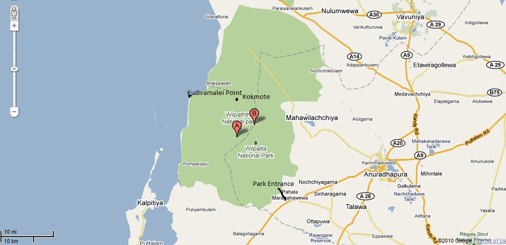
කාලාන්තරයක් ත්‍රස්තවාදී යුද්ධයේ සෙවනැල්ලට වැසී තිබූ ලංකාවේ විශාලතම වනජීවී උද්‍යානය වන විල්පත්තුව අද සාමාන්‍ය ජනතාවට විවෘතව ඇත. හෙක්ටයාර 131,000කට අධික භූමි ප්‍රමාණයකට උරුමකම් කියන විල්පත්තුව අනුරාධපුර, මන්නාරම් සහ පුත්තලම් දිස්ත්‍රික්කයන්ට අයත්ව පිහිටා තිබේ.

විල්පත්තුව පුරා ඝණව කටු පඳුරු හා තුරුවැල් පිහිටා ඇති අතර ඒ නිසාම අලි ඇතුන්ගේ ගහනය විල්පත්තුවේ කොටසකට සීමාවී පවතී. දිවියන්ගේත්, වලසුන්ගේත් තෝතැන්නක් ලෙස ප්‍රචලිත විල්පත්තුවේ විල්ලු 60ක් පමණ පිහිටා ඇති බව වාර්තා වේ. මුවන්, කුළු හරකුන්, කිඹුලන්, මොණරුන්, හිවලුන් මෙන්ම විවිධ පක්ෂි විශේෂ රාශියක්ද අපට විල්පත්තු වනෝද්‍යානය තුල දැකගන්නට හැකිය. මේ අතර ඉහත් කී විල්ලු 60න් 2ක් මුහුද හා කිසිඳු සම්බන්ධතාවයක් නොමැති වුවද කරදිය විල්ලු වීම විශේෂත්වයකි. අතීතයේදී මේ ප්‍රදේශයේ සිදු වූ භූ විපර්යාසයකින් මුහුද යට තිබූ ප්‍රදේශයක් වූ විල්පත්තුව ඉලිප්පී ඇති බව එක් මතයකි. ඒ මතයට තවත් හේතුවක් වනුයේ වනන්තරය පුරා මුහුදු වැලි විසිරී තිබීමයි. මේ වනන්තරය විවිධ ලක්ෂණ පෙන්නුම් කරන අතර වැලිමය ස්වභාවය නිසා කතරක සිරියක්ද වරෙක උසුලයි.

"කුදිරමලේ තුඩුව" | "Kudiramalei Point"

විජය කුමරුන් ගොඩ බස්නා ලදැයි කියැවෙන තම්බපණ්ණිය හෙවත් කුදිරමලේ තුඩුව විල්පත්තුවේ තවත් එක් ආකර්ෂණීය ස්ථානයකි. කුදිරමලේ තුඩුවේ භූ විෂමතාවය කාගේත් නෙත් සිත් ඇදගනු ඇත්තේ එහි වූ ගල් තලාවේ ස්වභාවයත් මුහුදට මායිම්ව අති අඩි 20ක පමණ දළ බෑවුමත් නිසාය. නොගැඹුරු, සුපැහැදිලි මුහුදේ විවිධාකාර මත්ස්‍ය විශේෂ ගැවසෙන අයුරු දක්නට හැකිය. කුදිරමලේ සිට බටහිර දෙස බැලූ විට කල්පිටිය සහ ඒ ආශ්‍රිත දූපත් දිස්වේ. කෙටි දුරක් උතුරට පාගමනින් ගිය විට විචිත්‍ර වෙරළ තීරයකට ළඟා විය හැකි අතර එහිදී ස්නානයටද අවකාශ හිමි වේ. වන රජදහන තුල අනේකවිධ නටඹුන් දැකිය හැකි අතර ඒ අතරින් කුවේණි මාළිගය ප්‍රමුඛස්ථානයක් ගනී. විශේෂයෙන්ම විජයාගමනය ආශ්‍රිත කාල වකවානුව තුල මෙම ප්‍රදේශය යක්ඛ ගෝත්‍රිකයන්ගේ මර්මස්ථානයක්ව තිබෙන්නට ඇති බව අනුමාන කළ හැකිය. මීට අමතරව ප්‍රාග් ඓතිහාසික වැදගත්කමකින් යුතු පොම්පරිප්පුවද විල්පත්තුව තුලම පිහිටියද අපි එහි යන කාලය (2010 අප්‍රේල්) වන විට ඒ ප්‍රදේශයේ ආරක්ෂාව තවමත් තහවුරු කර නොතිබිණි.

වනෝද්‍යානයට උදෑසනින්ම (පාන්දර 6) යෑම වැදගත්ය. මෑතදී විවෘත කෙරුණු නිසා තවමත් සතාසීපාව කුලෑටි ගති ලක්ෂණ පෙන්වයි. එනිසා ඔවුන් ක්‍රියාශීලී හිමිදිරියේ, මිනිස් හැසිරීම් අඩු විටදී සතුන් දැකීම වඩාත් පහසුය. දිවියකු, වලසකු දකින්නට නම් වාසනාව තිබිය යුතුමය. අප විල්පත්තු ගිය විට වලසකු දකින්නට පිං කර තිබුණත් දිවියන්ගේ පා සටහන්වලට එහා දෙයක් නුදුටුවෙමු. එය එසේ වෙතත් විල්පත්තු ගමන දිවියකු, වලසකු නුදුටුවත් මතකයෙන් නොමැකෙන සොඳුරු විනෝදබර ගමනක් වනු නිසැකය.

"තුරු ගොමු අතරින්..." | "Through green canopies..."
දහවල් ආහාරය වනෝද්‍යානය තුල පිසගෙන කෑමට අවකාශ වනජීවී දෙපාර්තුමේන්තුව විසින් ලබා දී ඇති අතර ඊට කදිමම ස්ථානය කොක්මොටය බංගලාවය. තනිකර දැවයෙන් නිමැවූ කොක්මෝටේ බංගලාව අදටත් අත හැර දමා තිබේ. මෝදරගම් ආරු නම් වූ ගංගාව අසබඩ පිහිටි දෙමහල් බංගලාව එක් පසෙකින් A අකුරේ හැඩයත් අනෙක් පසින් W අකුරේ හැඩයත් ගනී. කොක්මොටේ බංගලාව අසල ලබාගත් දහවල් ආහාරය ගත සිත ප්‍රබෝධවත් කරන්නක් විය. මෝදරගම් ආරුවද සෞන්දර්යයාත්මක මනරම් ජල පහරකි. නෑමට, විනෝදවන්නට කදිම තැනකි.

යුද්ධය පුරාවට විල්පත්තුවේ කොටි ක්‍රියාකාරකම් සිදු වී ඇති අතර වනජීවී නිලධාරීන් ඒ නිසා කොටින්ට දිවි පුදාද ඇති බව අපට අසන්නට ලැබුණි. ලංකාවේ විශිෂ්ටතම ඉංග්‍රීසි නවකතාකරුවකු වූ නිහාල් ද සිල්වා මහතා 2006දී මිය ගියේද විල්පත්තුවේදීමය. ඒ ඔහු ගමන්ගත් ජීප් රථය බිම් බෝම්බයකට හසු වීමෙනි. අදටත් එම රථයේ සුන්බුන් වනෝද්‍යානයේ දැකගන්නට පුළුවන. නිහාල් ද සිල්වා ලියූ The Road From Elephant Pass නවකතාවේ විශාල කොටසක් විල්පත්තුව ආශ්‍රිතව ලියැවී ඇත. එම කතාව 2009දී අලිමංකඩ නම් චිත්‍රපටයක් වශයෙන් එළිදැක්විනි. 2006දී වනෝද්‍යානය වසා දැමූ පසු බොහෝ සංචාරක බංගලා කොටි ලැගුම්හල් ලෙස භාවිතා වූ බවට අදටත් සාක්ෂි ශේෂව ඇත.

"බිම් බෝම්බයට ගොදුරු වූ ජීප් රියේ අවශේෂ කොටස්.." | "Debris from the bombed jeep.."
කෙසේ වෙතත් විල්පත්තුව තුල නවුක හමුදා කඳවුරක් ඉදිකිරීම හරහා පරිසරයට යම් හානියක් සිදු වී ඇති බව පෙනි යන්නේ නවුක හමුදාව විසින් තමන්ගේ ක්‍රීඩා අවශ්‍යතා සඳහා කැලය එළි කර තිබීමෙනි. මීට අමතර ප්‍රබල දේශපාලකයකුගේ මෙහෙයවීමෙන් අඩි 40ක් 50ක් පමණ තීරුවක් කැලයේ බටහිර ඉවුරට වන්නට කපා දමා තිබෙන්නේ මන්නාරමට අධිවේගී මාර්ගයක් තැනීමටය. එය හොඳ වුණත් ඒ හරහා විශාල පරිසර හානියක් සිදුවී ඇති අතර දිවියකු ඇතුළු සතුන් රැසකට ඒ ව්‍යාපෘතිය නිසා දිවි අහිමි වූ බවත් දැනගන්නට ලැබුණි. මේ මාර්ගයේ ප්‍රධාන අරමුණ කැලයේ දැව දේශපාලකයාට ලබා දී ඔහුගේ හෝටලයකට පිවිසුම් මාර්ගයක් ලබා දීම යැයිද රාවයක් පවතී. ඒ කෙසේ වෙතත් විල්පත්තුව ආරක්ෂා කිරීම ඔබ අප කාගේත් උත්තුංග වගකීමකි.

පිවිසෙන හැටි…

වනෝද්‍යානයට පිවිසුම පිහිටියේ පුත්තලම - අනුරාධපුර A12 මාරගයේ පුත්තලමේ සිට කි.මි. 30ක් පමණ ගිය තැන නොච්චියාගම නගරයට පෙරාතුව (අනුරාධපුරයේ සිට නම් පුත්තලම පාරේ කි.මි.40ක් පමණ ගොස් නොච්චියාගම පසු වූ පසු) වූ විල්පත්තු හන්දියෙන් වමට හැරී කි.මී 7ක් ගිය තැනය. ඔබ 4 වීල් රථයකින් නොපැමිණෙන්නේ නම් විල්පත්තු හන්දියෙන්ම රථයක් කතා කරගෙන ඒම සුදුසුය. සාමාන්‍යයෙන් උදෑසන 6 සිට සවස 6 දක්වා වනෝද්‍යානය වටා සැරිසැරීමට රු.7000ක් පමණ මුදලක් අය කෙරේ. මීට අමතරව ප්‍රවේශපත්‍ර ඇතුළු සෙසු ගාස්තු පිවිසුමේ පිහිටි ප්‍රධාන කාර්යාලයෙන් මිලදී ගත යුතුය.

අවට ආකර්ෂණයන්

සුප්‍රකට තබ්බෝව රක්ෂිතව පුත්තලමට ආසන්නයේ පිහිටා ඇති අතර අනෙක් පසින් අනුරාධපුරය ඓතිහාසික නගරය පිහිටා ඇත.

පහසුකම්

තවමත් විල්පත්තුව තුල නවාතැන් පහසුකම් අලුත්වැඩිය කර නැත. යුද්ධය නිසා අතැර දැමූ බංගලාවන් අලුත්වැඩියා කර නුදුරේදීම ජනතාවට ලබා දෙනු ඇතැයි අප ප්‍රාර්ථනා කරමු. එසේ ලබා දෙන දාට කොක්මොටේ බංගලාව සිහියේ තබා ගන්න. තනි දැවයෙන් ඉදි කළ ලෝකයේ වනෝද්‍යාන බංගලා කිහිපයෙන් එකක් වන එහි ලැගුම් ගැනීම සොඳුරු අත්දැකීමක් වනු ඇත. වනෝද්‍යානයෙන් පිටත විල්පත්තු හන්දිය, නොච්චියාගම හා කලාඔය ආශ්‍රිතව නවාතැන් කිහිපයක් ඇත. කෙසේ වෙතත් පුත්තලම හෝ අනුරාධපුර යන නගර ද්වයයේ අනිවාර්යයෙන් ඔබට නවාතැනක් සොයාගන්නට හැකිවනු ඇත.

"කොක්මොටේ බංගලාව" | "Kokmote Bungalow"
Due to the raging fires of war Wilpattu Wildlife Reserve was closed for a long time. But today the park which has an area exceeding 131,000 hectares has been reopened for the public. The park is the largest in Sri Lanka and has been split between Anuradhapura, Mannar & Puttalam Districts.

Wilpattu has been covered by dense shrubs and forests which has hindered the population of elephants to a segment of the park. Wilpattu which is equipped with close to 60 Villus has been renowned for its leopards and sloth bears. Deer, buffaloes, crocodiles, peacocks & fox as well as an assortment of birds are seen frequently in Wilpattu. Out of the 60 aforementioned Villus 2 are filled with Seawater despite having no connection to the sea whatsoever. It's believed that there was an earth shift thousands maybe millions of years back which has lifted the area of Wilpattu from the bottom of the sea. Another key factor that might support that theory is the presence of sea sand all over the park and the presence of sand dunes here and there.

"විල්ලුවක්" | "Villu"
The place where folklore points out to be the location to where Prince Wijeya landed is located within Wilpattu. In English its called the Horse point, but commonly referred to in Sinhala as Kudiramalei. Kudiramalei is one fascinating point with a precipice to the sea of about 20 feet and a quite intriguing formation of rocks about. Kalpitiya and the island chain there is clearly visible on the western horizon while a small journey on foot northwards will take us to a very calm and pristine beach which could be used for a bathe as well. Many ruins are to be seen around the park and one of them is the Quweni Palace. This area is believed to have been an epicenter of the Yakka community in the time period leading upto the landing of Prince Wijeya. Another location, Pomparippu, is a point with lots of prehistoric importance but by April of 2010 access to Pomparippu was not allowed as security forces were still scanning the area for potential dangers.

It's best to come to the park early morning (approx 6am). Since the park was reopened recently the animals are still very much shy to the presense of vehicles and humans. Getting a headstart in the morning where animal are very active would be a bonus to see some creatures. You need to possess a lot of luck to glimpse a leopard or a sloth bear. We were lucky enough to witness a sloth bear on our visit although the closest we saw of a leopard were its paw prints. Even if you won't see a leopard or a sloth bear the adventurous journey to Wilpattu will be unforgettable.

You will be allowed to prepare food within the park by the Wildlife Department, and the best location for that is the Kokmote Bunglow which is a structure made solely out of timber. Now abandoned it handsomely stands on the banks of the Moderagam Aru river resembling letter "A" on one side while resembling a "W" on the other. Having lunch at Kokmote will definitely rejuvenate your soul. The Moderagam Aru is also a serene waterway fit for a dip in the water and some fun as well.

 
"මෝදරගම් ආරු" | "Moderagam Aru"
The LTTE terrorists have run havoc within the park boundaries during their insurgent years and several park rangers have been killed in the process. One of Sri Lanka's prolific English novelists, Nihal De Silva passed away in 2006 when the jeep he was travelling in fell victim to a landmine explosion. Still remains of the jeep can be seen there. Nihal De Silva in his Graetian Prize Winning novel "The Road from Elephant Pass" depicts a lot of facts and sceneries based in Wilpattu. This book came alive as a Sinhala movie in 2009 under the name Alimankada. Its evident that the bunglows had served as makeshift LTTE hideouts since the parks closure in 2006.

Anyhow a Sri Lanka Navy base has been established within the park and they have destroyed parts of the forest for their requirements. Besides that a road clearance amounting to about 40-50 feet has been made by a leading politician under the banner of building a highway to Mannar. Due to this it is said that many creatures have lost their lives including a leopard, which is sad. There are other rumors that the said politician is only clearing the the road to a hotel he's constructing and to reap the timper. Either way safeguarding and protecting the Wilpattu National Park is an important responsibility for all Sri Lankans alike.

"වන විනාශය" | "Deforestation"

How to get there

The entrance to Wilpattu can be found on the the A12 road connecting Puttalam & Anuradhapura. From Puttalam travelling 30km in the direction of Anuradhapura will get you to Wilpattu junction, from there take a left turn and travel 7km to the main office (from Anuradhapura side drive 40km towards Puttalam, you'll get to Wilpattu junction just after passing Nocchiyagama). If you don't have a 4WD vehicle its better to rent one at Wilpattu junction itself. A jeep will cost about Rs.7000/= for the whole days journey (6am to 6pm). Tickets and other payments must be made at the main office at the park entrance.

Nearby attractions

The famous Thabbowa Reserve is located close to Puttalam town while on the other side Anuradhapura, one of our ancient capitals is seen.

Facilities

Still the circuit bungalows in Wilpattu hasn't been rehabilitated. We can only be hopeful that they'll be repaired and reopened to the public in the near future. Keep Kokmote Bunglow in your mind for its a serene place made fully out of wood. Accomodations could be found in places like Wilpattu junction, Nocchiyagama & KalaOya in the vicinity, while in Puttalam & Anuradhapura you'll be able to get accomodation in abundance.